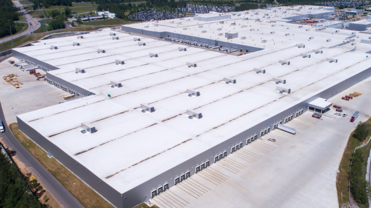
Send a technician across a 70,000-square-foot warehouse roof and you get an inspection limited by what the eye catches from standing height and what the schedule allows the crew to reach. Whole bays go unlooked-at, every step adds wear to a membrane that needed none, and the report reflects a sampling, not the roof. We fly these roofs instead. A drone covers the entire surface on a repeatable grid, captures every drain sump, lap seam, curb, and penetration in high resolution, and produces that record before we commit a single person to a deck whose condition is still an open question. On storm-struck or visibly aging roofs, that sequence is also a safety decision we would much rather make from photographs than from underfoot.
Spokane has no shortage of roofs built for exactly this approach. The logistics and flex-industrial buildings ringing Spokane International, the large retail boxes strung along Sprague Avenue and the Sullivan Road corridor in the Valley, the older institutional roofs near Gonzaga and through the University District, and the warehouse stock tucked into the East Central and Hillyard industrial pockets are all big, flat, and genuinely hard to inspect on foot. On roofs like these, an aerial pass converts a full day of partial coverage into a couple of hours of complete, time-stamped documentation.
The Thermal Sensor Earns Its Keep, Not the Camera
The high-resolution camera is useful, but the payload that changes the diagnosis is the infrared sensor. Trapped moisture is what quietly destroys low-slope roofs, and it rarely shows itself on the surface. When water migrates into the insulation through a split seam, a tired penetration, or a failed flashing, that saturated board stores and releases heat on a different schedule than the dry insulation surrounding it. We fly during the evening cooldown after a clear, dry day, and as the roof radiates its stored heat into the night, the wet zones stay warm longer and light up on the thermal image. That signature traces the precise footprint of saturated insulation sitting beneath a membrane that still looks perfectly intact from above, which is something no walkover can reproduce across a large roof.
That moisture map is what drives the only question that matters: do you cut out and recover the wet areas, or has the saturation spread far enough that an honest answer is a full tear-off? In Spokane the freeze-thaw cycle makes that call time-sensitive. Water trapped in the insulation freezes through the winter, expands, breaks down the board and the adhesion holding it, then thaws and creeps outward the next cycle. A modest wet zone found in the fall is a contained, plannable repair. The same zone left two winters drifts into a structural and budget problem. Infrared scanning catches it while the scope is still small and the number is still small.
The Scan Only Works When the Conditions Cooperate
Thermal roof imaging is not point-and-shoot. It depends on a real temperature differential between wet and dry insulation, and that differential is strongest during the cooldown window after a clear, dry day with decent solar gain. A damp surface, recent rain, heavy overcast, or simply flying at the wrong hour will wash the signal out and leave you with an attractive thermal picture that means nothing diagnostically. We schedule flights around Spokane's actual weather so the scan produces evidence, not decoration.
Flying It Legally, Flying It Safely
Commercial drone operation is regulated, and we run every flight under FAA Part 107 with a certificated remote pilot in command. That matters here because parts of Spokane sit inside controlled airspace around Spokane International and Felts Field, and inspections in those zones require LAANC authorization before we can launch. We secure those authorizations, hold visual line of sight throughout, brief the site, and keep the aircraft clear of people and neighboring property. For the owner, the difference is an inspection that is documented, insured, and defensible, rather than a hobbyist quadcopter with no paperwork behind it.
Reports an Adjuster or a Capital Planner Can Actually Use
After a wind or hail event, the real value of the flight is the record it produces. We deliver GPS-tagged imagery that pins impact locations and density, lifted or displaced membrane, damaged flashings and rooftop units, and overall surface condition, organized the way commercial property carriers expect to receive it. That package goes straight to the adjuster and carries the claim on its own, without anyone translating a verbal description into a scope. For storm response we move these flights to the front of the line and can usually turn documentation around within a day or two of the event, weather permitting.
The same dataset does double duty for capital planning. When you are budgeting a replacement, aerial data confirms true roof area, locates every penetration and curb, and records existing conditions, so the specification and the bids rest on measured fact instead of assumptions scaled off an old drawing. That alone cuts the requests for information and the change orders once a crew is finally on the roof.
- Complete high-resolution coverage on a consistent grid with zero crew foot traffic on the membrane.
- Infrared moisture mapping that locates saturated insulation hidden under an intact-looking sheet.
- FAA Part 107 flights with LAANC authorization where required near Spokane International and Felts Field.
- GPS-tagged, carrier-formatted documentation built for wind and hail claims.
- Verified roof area and penetration counts to anchor reroof specifications and budgets.
Questions Spokane Owners Ask About Drone Roof Inspections
How is flying the roof better than walking it?
It covers the whole surface systematically, leaves a complete photographic record, and spares the membrane the foot traffic a walkover puts on it. On large or unknown-condition roofs it is also the safer call, and the infrared moisture map across a big roof is simply something a person on foot cannot produce at all.
Can thermal imaging genuinely find hidden water?
Yes, when it is flown correctly. During the evening cooldown after a clear, dry day, the sensor reads wet insulation as a warm anomaly because it gives up stored heat slower than the dry board around it. The resulting map is precise enough to scope a targeted cut-and-recover against a full replacement.
Do you need authorization to fly over our building?
In the controlled airspace around Spokane International or Felts Field, yes. We obtain LAANC authorization wherever it is required and run every job under FAA Part 107 with a certificated remote pilot, holding visual line of sight and staying clear of people and adjacent property.
Which roofs get the most out of an aerial inspection?
Large, low-slope commercial roofs: warehouses, distribution centers, retail boxes, office complexes, and multi-building campuses. On a small or steep roof a quick manual look usually suffices. Past roughly ten thousand square feet, the drone is both faster and far more thorough.
How quickly can you document storm damage for a claim?
Routine inspections schedule within a few business days. After a significant wind or hail event we prioritize claim flights and can typically deliver GPS-tagged, carrier-ready documentation within twenty-four to forty-eight hours, weather permitting.